Für iPhone & iPadFor iPhone & iPad

Jeder Aufnahmeort.
Nachweisbar dokumentiert.

Every location.
Documented & verifiable.

GeoPhoto Pro verwandelt dein iPhone in eine professionelle Dokumentationskamera: GPS-Koordinaten, Adresse und Zeit direkt im Foto – plus Projekte, teilbare PDF-Berichte und iCloud-Sync.

GeoPhoto Pro turns your iPhone into a professional documentation camera: GPS coordinates, address and time right on the photo – plus projects, shareable PDF reports and iCloud sync.

Gratis laden · Pro mit 7 Tagen gratisFree to download · 7-day Pro trial Kein Konto · kein TrackingNo account · no tracking Deutsch & EnglischGerman & English
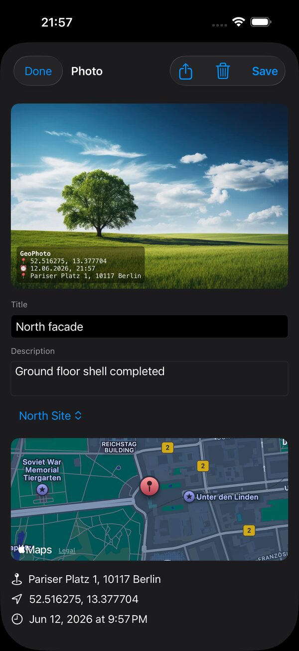
GeoPhoto Pro – Foto-Detail mit GPS-Wasserzeichen und Karte
Echtes GeotaggingTrue geotagging PDF-Berichte mit KartePDF reports with maps iCloud-SynciCloud sync Local-first & privatLocal-first & private
FunktionenFeatures

Alles für die Vor-Ort-Doku

Everything for on-site documentation

Aufnehmen, verorten, organisieren, teilen – in einer einzigen App.

Capture, locate, organize, share – in a single app.

GPS-Wasserzeichen

GPS watermark

Koordinaten, Adresse und Aufnahmezeit werden direkt ins Foto eingebrannt – fälschungssicher sichtbar.

Coordinates, address and capture time are burned right into the photo – visibly tamper-evident.

Echtes Geotagging

True geotagging

GPS & EXIF werden eingebettet – deine Fotos erscheinen in der Foto-App direkt auf der Karte.

GPS & EXIF are embedded – your photos appear right on the map in the Photos app.

Karten-Einblendung

Map overlay

Optional eine kompakte Karte des Aufnahmeorts direkt im Bild – der Kontext bleibt erhalten.

Optionally embed a compact map of the location right in the image – context stays attached.

Projekte

Projects

Fotos sauber nach Bauvorhaben, Objekt oder Auftrag organisieren – nichts geht mehr unter.

Keep photos neatly organized by project, property or job – nothing gets lost.

PDF-Berichte

PDF reports

Teilbare Berichte mit Übersichtskarte und Detailseiten – professionell, in einem Tap.

Shareable reports with an overview map and detail pages – professional, in one tap.

iCloud-Sync & Privatsphäre

iCloud sync & privacy

Optionaler Abgleich über deinen privaten iCloud-Container. Kein Konto, kein Tracking.

Optional sync via your private iCloud container. No account, no tracking.

KameraCamera

Aufnahme mit allem Komfort

Capture with full control

Eine schnelle, fokussierte Kamera, die fürs Feld gemacht ist. Belichtung, Fokus und Bildausschnitt im Griff – Hoch- und Querformat inklusive.

A fast, focused camera built for the field. Exposure, focus and framing under control – portrait and landscape included.

  • Objektivwahl, Tap-to-Focus & BelichtungLens selection, tap-to-focus & exposure
  • Raster, Timer & SeitenverhältnisseGrid, timer & aspect ratios
  • Schnelles Speichern, auch im QuerformatFast saving, even in landscape
GeoPhoto Pro Kamera
Foto-DetailPhoto detail

Jeder Beleg, lückenlos belegt

Every shot, fully traceable

Titel, Beschreibung, exakte Koordinaten, Adresse und Zeitstempel – plus eine Karte des Aufnahmeorts. Alles zusammen, alles nachvollziehbar.

Title, description, exact coordinates, address and timestamp – plus a map of the location. All together, all verifiable.

  • Eingebranntes GPS-WasserzeichenBurned-in GPS watermark
  • Adresse & Koordinaten automatischAddress & coordinates automatically
  • Titel & Notiz je FotoTitle & note per photo
GeoPhoto Pro Foto-Detail mit Karte
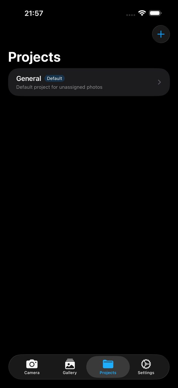
Projekte & BerichteProjects & reports

Vom Foto zum fertigen Bericht

From photo to finished report

Organisiere Aufnahmen nach Projekt und exportiere mit einem Tap einen sauberen PDF-Bericht mit Übersichtskarte – ideal zum Weitergeben an Kunden, Auftraggeber und Versicherung.

Organize shots by project and export a clean PDF report with an overview map in one tap – perfect to hand to clients, contractors and insurers.

  • Beliebig viele Projekte (Pro)Unlimited projects (Pro)
  • PDF mit Übersichts- & DetailseitenPDF with overview & detail pages
  • Teilen in einem TapShare in one tap
GeoPhoto Pro Projekte
So funktioniert'sHow it works

In drei Schritten zur Doku

Documentation in three steps

Kein Setup, kein Konto. Öffnen und loslegen.

No setup, no account. Open and go.

Aufnehmen

Capture

Foto schießen – GPS, Adresse und Zeit werden automatisch erfasst und als Wasserzeichen eingebrannt.

Take a photo – GPS, address and time are captured automatically and burned in as a watermark.

Organisieren

Organize

Ordne Fotos einem Projekt zu, ergänze Titel und Notizen – alles bleibt sauber sortiert.

Assign photos to a project, add titles and notes – everything stays neatly sorted.

Teilen

Share

Exportiere einen PDF-Bericht mit Karte oder synchronisiere via iCloud auf all deine Geräte.

Export a PDF report with a map or sync via iCloud across all your devices.

Gemacht für die PraxisBuilt for the field
Bau & HandwerkConstruction & trades ImmobilienReal estate VermessungSurveying GutachtenInspections VersicherungInsurance AußendienstField service
PreisePricing

Einfach & fair

Simple & fair

Kostenlos starten. Pro freischalten, wann du willst – Abo oder einmalig.

Start for free. Unlock Pro whenever you like – subscription or one-time.

Gratis

Free

Dauerhaft kostenlos

Free forever

  • Kamera mit GPS-WasserzeichenCamera with GPS watermark
  • Echtes Geotagging & GalerieTrue geotagging & gallery
  • iCloud-SynchronisationiCloud sync
  • Standard-ProjektDefault project
Kostenlos ladenDownload free
7 Tage gratis7 days free

GeoPhoto Pro

Alle Premium-Funktionen freigeschaltet

All premium features unlocked

  • PDF-Berichte mit KartePDF reports with map
  • Beliebig viele ProjekteUnlimited projects
  • Karten-Wasserzeichen & Zusatz-StileMap watermark & extra styles
MonatMonthly2,99 €
JahrYearly24,99 €
Lifetime29,99 €
Pro testenTry Pro

Abos verlängern sich automatisch, jederzeit kündbar. Lifetime: einmalig zahlen, dauerhaft nutzen.

Subscriptions auto-renew, cancel anytime. Lifetime: pay once, keep forever.

PrivatsphärePrivacy

Privatsphäre zuerst

Privacy first

GeoPhoto Pro ist local-first: Deine Fotos und Projekte bleiben auf deinem Gerät bzw. in deinem privaten iCloud-Konto. Keine Nutzerkonten, kein Tracking, keine Weitergabe an Dritte.

GeoPhoto Pro is local-first: your photos and projects stay on your device or in your private iCloud account. No user accounts, no tracking, no sharing with third parties.

Datenschutzerklärung ansehen →Read the privacy policy →

Local-first

Local-first

Daten bleiben auf deinem Gerät – nicht auf fremden Servern.

Your data stays on your device – not on third-party servers.

Kein Tracking

No tracking

Keine Analytics-SDKs, keine Werbe-IDs, keine Profile.

No analytics SDKs, no ad IDs, no profiling.

Dein iCloud

Your iCloud

Sync läuft über deinen privaten iCloud-Container – ohne Konto bei uns.

Sync runs through your private iCloud container – no account with us.

FAQ

Häufige Fragen

Frequently asked

Funktioniert GeoPhoto ohne Internet?Does GeoPhoto work offline?

Ja. Aufnahme, GPS-Wasserzeichen, Geotagging und Berichte funktionieren komplett offline. iCloud-Sync läuft, sobald wieder eine Verbindung besteht.

Yes. Capture, GPS watermark, geotagging and reports work fully offline. iCloud sync resumes as soon as you're back online.

Was ist kostenlos, was ist Pro?What's free, what's Pro?

Kamera mit GPS-Wasserzeichen, Geotagging, Galerie und iCloud-Sync sind kostenlos. Pro schaltet PDF-Berichte, beliebig viele Projekte sowie Karten-Wasserzeichen und Zusatz-Stile frei.

The camera with GPS watermark, geotagging, gallery and iCloud sync are free. Pro unlocks PDF reports, unlimited projects, and the map watermark plus extra styles.

Werden meine Fotos an euch übertragen?Are my photos sent to you?

Nein. GeoPhoto ist local-first. Deine Fotos und Projekte bleiben auf deinem Gerät bzw. in deinem privaten iCloud-Container. Es gibt kein Nutzerkonto bei uns und kein Tracking.

No. GeoPhoto is local-first. Your photos and projects stay on your device or in your private iCloud container. There's no account with us and no tracking.

Erscheinen die Fotos in der Foto-App auf der Karte?Do photos appear on the map in Photos?

Ja. GeoPhoto bettet echte GPS-/EXIF-Daten ein, daher erscheinen deine Aufnahmen in der Apple Foto-App ganz normal auf der Karte.

Yes. GeoPhoto embeds real GPS/EXIF data, so your shots appear on the map in Apple Photos as usual.

Kann ich die Pro-Abos kündigen?Can I cancel the Pro subscription?

Ja, jederzeit über die App-Store-Einstellungen. Es gibt 7 Tage gratis, danach verlängert sich das Abo automatisch. Alternativ gibt es einen einmaligen Lifetime-Kauf.

Yes, anytime via your App Store settings. There's a 7-day free trial, after which it auto-renews. Alternatively, a one-time lifetime purchase is available.

RechtlichesLegal

Impressum

Legal Notice

Angaben gemäß § 5 Digitale-Dienste-Gesetz (DDG).

Information pursuant to § 5 of the German Digital Services Act (DDG).

Anbieter & VerantwortlicherProvider & controller Rene Süß
Barbarossastraße 91
09112 Chemnitz
DeutschlandGermany
KontaktContact Telefon:Phone: +49 151 55386821
E-Mail:E-mail: support@gcng.de

Berufliche Stellung: Freiberufler. Als Kleinunternehmer im Sinne von § 19 UStG wird keine Umsatzsteuer ausgewiesen; eine USt-IdNr. liegt nicht vor.

Professional status: Freelancer. As a small business under § 19 of the German VAT Act (UStG), no value-added tax is charged and no VAT ID exists.

Inhaltlich verantwortlich nach § 18 Abs. 2 MStV: Rene Süß (Anschrift wie oben).

Responsible for content (§ 18 (2) MStV): Rene Süß (address as above).

Verbraucherstreitbeilegung: Wir sind nicht bereit und nicht verpflichtet, an Streitbeilegungsverfahren vor einer Verbraucherschlichtungsstelle (§ 36 VSBG) teilzunehmen.

Consumer dispute resolution: We are neither willing nor obliged to participate in dispute resolution proceedings before a consumer arbitration board (§ 36 VSBG).

Dokumentiere, das was zählt.

Document what matters.

Lade GeoPhoto Pro und halte jeden Aufnahmeort nachweisbar fest – gratis starten, Pro 7 Tage testen.

Get GeoPhoto Pro and document every location verifiably – start free, try Pro for 7 days.